Pentraeth

Pentraeth

Pentraeth

53°17′01″N 4°13′01″W / 53.28373, -4.21695

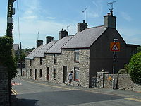
Nant Terrace, Pentraeth

Pentraeth es un pueblo en la isla de Anglesey (en galés: Ynys Môn), al norte de Gales. El código postal del Royal Mail empieza por LL75.

Su nombre en galés significa al final de (o principio de) una playa, y se localiza cerca de Traeth Coch (Bahía Muelle Rojo). Hay un pequeño río, Afon Nodwydd, que lo atraviesa. El antiguo nombre del pueblo era Llanfair Betws Geraint. En 1170 fue el sitio de una batalla cuando Hywel ab Owain Gwynedd desembarcó con una armada alzada en Irlanda en un intento de proclamar una parte del reino de Gwynedd tras la muerte de su padre Owain Gwynedd. Fue derrotado y asesinado aquí por las fuerzas de sus semi-hermanos Dafydd ab Owain Gwynedd y Rhodri.

En 1859, Charles Dickens permaneció en el pueblo durante su viaje, como periodista del The Times, para visitar el naufragio del Moelfre. Una vez hubo una estación de ferrocarril en el pueblo, sobre la línea rama Bahía Muelle Rojo.

La localidad tiene un equipo de fútbol (Pentraeth F.C.) que juega en la Liga de Anglesey, y ganó la Copa Megan en 2005/06.

Enlaces externos

Obtenido de "Pentraeth"

Wikimedia foundation. 2010.

Игры ⚽ Нужен реферат?

Mira otros diccionarios:

  • Pentraeth — is a village on the island of Anglesey ( Ynys Môn ), north Wales, at gbmapping|SH523786. The Royal Mail postcode begins LL75.Its Welsh name means at the end of (or head of) a beach , and it is located near Traeth Coch (Red Wharf Bay). There is a… …   Wikipedia

  • Pentraeth — 53° 17′ 01″ N 4° 13′ 01″ W / 53.28373, 4.21695 Pentraeth …   Wikipédia en Français

  • Dolly Pentraeth — Dolly Pentreath Dolly Pentreath était une marchande de poisson du XVIIIe siècle, réputée être la dernière locutrice courante de la langue cornique. Eteinte en 1777, elle est devenue une figure légendaire des militants linguistiques de… …   Wikipédia en Français

  • Anglesey — For other places with the same name, see Anglesey (disambiguation). Isle of Anglesey Ynys Môn Geography Area Total  % Water …   Wikipedia

  • Anglesey — Área Principal de Anglesey Ynys Môn Geografía Área Total  % Agua 9º 714 km² 0.7% Sede adminis …   Wikipedia Español

  • Trefriw — infobox UK place country = Wales welsh name= constituency welsh assembly= map type= official name= Trefriw population= 1,338 (2001 census) unitary wales= Conwy lieutenancy wales= Clwyd constituency westminster= Meirionnydd Nant Conwy post town=… …   Wikipedia

  • Hywel ab Owain Gwynedd — (died 1170) was a Welsh poet and military leader. Hywel was the illegitimate son of Owain Gwynedd, prince of Gwynedd, and an Irishwoman named Pyfog. In recognition of this, he was also known as Hywel ap Gwyddeles (=Hywel son of the Irishwoman).… …   Wikipedia

  • Anglesey League — The Anglesey Football League (currently the Stena Line Anglesey Football League , for sponsorship reasons) is a football league and is equivalent to the fifth level of the Welsh football league system in North Wales. The champions are promoted to …   Wikipedia

  • Isle of Anglesey County Council — The Isle of Anglesey County Council (Welsh: Cyngor Sir Ynys Môn) is the governing body for the county of Anglesey, one of the unitary authority areas of Wales. The council consists of 40 councillors, representing 40 electoral wards. Contents 1… …   Wikipedia

  • Red Wharf Bay branch line — The Red Wharf Bay branch line was a standard gauge railway line in Anglesey, Wales and branched off the Anglesey Central Railway. It was the last standard gauge passenger line to open in North Wales,Rear; 1994] in 1908, but it closed to… …   Wikipedia

Compartir el artículo y extractos

Link directo
Do a right-click on the link above
and select “Copy Link”