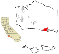
Goleta, California — Infobox Settlement official name = City of Goleta, California other name = native name = nickname = settlement type = CDP motto = |375px|Goleta, looking southwest from the Santa Ynez Mountains. Old Town Goleta is at the right, and the Santa… … Wikipedia
Goleta — may refer to: * Goleta, California * Goleta (genus) , a spider genus … Wikipedia
Goleta Slough — The Goleta Slough is an area of estuary, tidal creeks, tidal marsh, and wetlands near Goleta, California, USA. It primarily consists of the filled and unfilled remnants of the historic inner Goleta Bay about 8 miles (13 km) west of Santa Barbara … Wikipedia
Goleta Depot — Infobox nrhp | name =Goleta Depot nrhp type = caption = Goleta Depot, 2006. location= 300 North Los Carneros Road, Goleta, CA lat degrees = 34 | lat minutes = 26 | lat seconds = 34.24 | lat direction = N long degrees = 119 | long minutes = 51 |… … Wikipedia
Goleta (Amtrak station) — Infobox Station name= Goleta type= image size= image caption= address= 25 S. La Patera Ln. Goleta, California 93117 coordinates= line= rail color box| system=Amtrak| line=Pacific Surfliner other= structure= platform= depth= levels= tracks=… … Wikipedia
Goleta Valley Junior High — Infobox School imagesize=90px name=Goleta Valley Jr. High School type=Public location=6100 Stow Canyon Road. Goleta, CA country=USA information=(805) 967 3486 established=1964 [ [http://www.gvjh.org/ourschool/index.html GVJH History ] ] grades=7… … Wikipedia
Goleta — Para la localidad estadounidense, véase Goleta (California). Etoile, goleta de velacho de dos mástiles de la Armada Francesa, utilizada para instrucción naval … Wikipedia Español
California locations by per capita income — All figures as of the censusGR|2 of 2000 by the United States Census Bureau.California is the thirteenth richest state in the United States of America, with a per capita income of $22,711 (2000). California counties ranked by per capita income… … Wikipedia
Goleta Union School District — (G.U.S.D. or GUSD) is a school district serving the Goleta valley, a suburban community of 80,000 people which includes the newly formed City of Goleta and a large unincorporated area. The valley lies between the Santa Ynez Mountains and the… … Wikipedia
Goleta — Goleta, CA U.S. Census Designated Place in California Population (2000): 55204 Housing Units (2000): 20442 Land area (2000): 26.261243 sq. miles (68.016303 sq. km) Water area (2000): 0.098793 sq. miles (0.255873 sq. km) Total area (2000):… … StarDict's U.S. Gazetteer Places


 Estados Unidos
 California


