- Säntis
-
Säntis 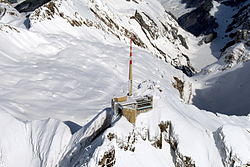
Cumbre de Säntis.
 Säntis
Ubicación  Suiza
Suiza• Coordenadas Coordenadas: Altitud 2.502 msnm Sierra Alpstein Cordillera Prealpes appenzelleses Prominencia 2.021 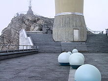 Instalación de Swisscom en la cumbre de Säntis.
Säntis (2.502 msnm) es una montaña en la sierra de Alpstein de los Prealpes appenzelleses en Suiza. Puede alcanzarse por teleférico desde Schwägalp.
El pico es el punto más alto de los cantones de cantón de Appenzell Rodas Interiores y cantón de Appenzell Rodas Exteriores, y también es compartido por el cantón de San Galo.
Desde la torre de transmisión de Swisscom (123,55 m), se retransmiten varios programas de radio VHF y televisión (SF1, SF2) de SRG SSR idée suisse.
Säntis es también el nombre de un cantón de la República Helvética, el Cantón de Säntis, que existió entre 1798 y 1803, formado por el territorio de San Galo, Appenzell y Rheintal. Su capital era San Galo.
Tiempo
 Parámetros climáticos promedio de Säntis
Mes Ene Feb Mar Abr May Jun Jul Ago Sep Oct Nov Dic Anual Temperatura diaria máxima (°C) -4.6 -5 -4.1 -1.9 2.3 5.6 8.2 8.2 6.6 4.1 -1 -3.2 1.3 Temperatura diaria promedio (°C) -7.9 -8.1 -7.2 -4.8 -0.7 2.3 4.7 4.6 3.1 0.7 -4.4 -6.7 -2 Temperatura diaria mínima (°C) -10.3 -10.6 -9.5 -6.9 -2.6 0.4 2.8 2.9 1.2 -1.2 -6.6 -9.1 -4.1 Precipitación total (mm) 234 196 200 223 199 250 270 288 206 174 212 248 2701 Días de precipitaciones (≥ 1 mm) 14.9 13.2 15.1 15.5 16 17.1 16 15.9 11.8 10.4 12.4 13.9 172.2 Fuente: MeteoSchweiz[1] 08-05-2009 Referencias
- ↑ «Temperature and Precipitation Average Values-Table, 1961-1990» (en alemán, francés, italiano). Federal Office of Meteorology and Climatology MeteoSwiss. Consultado el 08-05-2009.
- Este artículo fue creado a partir de la traducción del artículo Säntis de la Wikipedia en inglés, bajo licencia Creative Commons Atribución Compartir Igual 3.0 y GFDL.
Enlaces externos
 Wikimedia Commons alberga contenido multimedia sobre SäntisCommons.
- Säntis en SummitPost
- Säntis Sepp-Webcam
- Säntis-Schwebebahn AG (en alemán)
- Säntis: imágenes
Categorías:- Montañas de los Alpes
- Montañas de San Galo
- Montañas de Appenzell Rodas Interiores
- Montañas de Appenzell Rodas Exteriores
- Turismo en Suiza
- Teleféricos
- Prealpes suizos


Wikimedia foundation. 2010.