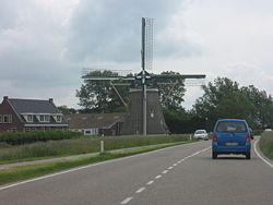
Moriaanshoofd — Town … Wikipedia
Moriaanshoofd — 51°41′18″N 3°50′57″E / 51.68833, 3.84917 … Wikipédia en Français
Schouwen-Duiveland — Héraldique … Wikipédia en Français
Schouwen-duiveland — Schouwen Duiveland … Wikipédia en Français
Schouwen-Duiveland — Infobox Settlement official name = Schouwen Duiveland mapsize = 280px subdivision type = Country subdivision name = Netherlands subdivision type1 = Province subdivision name1 = Zeeland area footnotes = (2006) area total km2 = 488.94 area land km2 … Wikipedia
Kinderdijk — Coordinates: 51°53′N 4°38′E / 51.883°N 4.633°E / 51.883; 4.633 … Wikipedia
De Adriaan, Haarlem — Windmill De Adriaan De Adriaan is a windmill in the Netherlands that burnt down in 1932 and was rebuilt in 2002. The original windmill dates from 1779 and the mill has been a distinctive part of the skyline of Haarlem for centuries. Contents … Wikipedia
List of ships of the line of the Dutch Republic — This is a list of Dutch (United Provinces of the Netherlands) sailing warships: The Dutch were often handicapped by the smaller size of their ships relative to the vessels of other nations, particularly those of England and France. This was due… … Wikipedia
Rijksweg 59 — Vorlage:Infobox hochrangige Straße/Wartung/NL AN Autosnelweg A59/Autoweg N59 in den Niederlanden … Deutsch Wikipedia
Schouwen-Duiveland — Gemeinde Schouwen Duiveland Flagge Wappen Provinz Zeeland … Deutsch Wikipedia
 Localización de Moriaanshoofd en Países Bajos
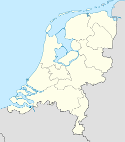
 Moriaanshoofd
 Países Bajos
