Harstine Island (Washington)
Mira otros diccionarios:
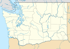
Harstine Island, Washington — Harstine Island is an unincorporated community in Mason County, Washington, United States, located on a similarly named island. The island is located west of Case Inlet in southern Puget Sound, 16 km (10 miles) north of Olympia. It has a land… … Wikipedia
Clark Island (Washington) — Clark Island is an island in the San Juan Islands of the U.S. state of Washington. It is located near Barnes Island off the northeast coast of Orcas Island. Clark Island Marine State Park encompasses the entire 55 acre (22 ha) island, seven… … Wikipedia
Washington Natural Areas Program — The Washington Natural Areas Program, part of the Washington Department of Natural Resources, manages dozens of natural areas owned by the US state of Washington. These areas have received funding through the state s general fund since the… … Wikipedia
National Register of Historic Places listings in Washington — AD AS BE CH CM … Wikipedia
Mason County, Washington — Location in the state of Washington … Wikipedia
McMicken Island State Park — in Mason County, Washington is a Washington State Park accessible only by boat.[1] It consists of the 11.5 acres (4.7 ha) of forested McMicken Island in south Puget Sound, including 1,661 feet (506 m) of saltwater shoreline with a… … Wikipedia
Squaxin Island Tribe — (also Squaxin, Squaxon) is a Native American tribe in western Washington state in the United States. The Squaxin Island tribe is made up of several subtribes: the Noo Seh Chatl, Steh Chass, Squi Aitl, Sawamish/T Peeksin, Sa Heh Wa Mish, Squawksin … Wikipedia
McMicken Island State Park — ist ein 4,7 Hektar großer State Park im Mason County im US Bundesstaat Washington. Die Insel liegt im südlichen Puget Sound östlich von Harstine Island, hat über 500 Meter Küstenlinie und ist in erster Linie nur per Boot zu erreichen. Nur bei… … Deutsch Wikipedia
Matia Island — is an island in the San Juan Islands of the U.S. state of Washington. The Island s entire 145 acres (159 actual) comes under the protection of the U.S. Fish and Wildlife Service and is cooperatively managed by the Washington State Parks and… … Wikipedia
List of unincorporated communities in Washington — This is a list of unincorporated communities in the U.S. state of Washington which are not incorporated municipalities. Incorporated municipalities in the state are listed separately in a list of cities and list of towns. Contents 1 Census… … Wikipedia
 Harstine Island
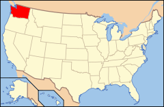
 Estados Unidos
 Washington
 Portal:Washington. Contenido relacionado con Washington.
 Wikimedia Commons alberga contenido multimedia sobre Harstine Island (Washington). Commons
