Chimacum, Washington — Chimacum is an unincorporated community in eastern Jefferson County, Washington, United States. It lies on the Olympic Peninsula. It was named after the Chimakum (also spelled Chemakum or Chimacum) group of Native Americans that lived there until … Wikipedia
National Register of Historic Places listings in Jefferson County, Washington — List of entries on the National Register of Historic Places in Jefferson County, Washington See also National Register of Historic Places listings in Washington This National Park Service list is complete through NPS recent listings posted… … Wikipedia
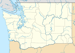
Jefferson County, Washington — Location in the state of Washington … Wikipedia
List of high schools in Washington — This is a list of high schools in the state of Washington.Adams County*Lind Junior Senior High School, Lind *Othello High School, Othello *Ritzville High School, Ritzville * [http://www.tucna.wednet.edu/default.aspx Washtucna High School,… … Wikipedia
Port Townsend, Washington — Infobox Settlement official name = Port Townsend, Washington settlement type = City nickname = motto = imagesize = 250px image caption = The heart of downtown Port Townsend, seen from the water image image mapsize = 250px map caption = Location… … Wikipedia
Discovery Bay, Washington — View of Discovery Bay near sunset, looking north with the San Juan Islands in the background Discovery Bay is: A small bay adjoining the Strait of Juan de Fuca on the Olympic Peninsula in Washington State; this body of water was also historically … Wikipedia
List of unincorporated communities in Washington — This is a list of unincorporated communities in the U.S. state of Washington which are not incorporated municipalities. Incorporated municipalities in the state are listed separately in a list of cities and list of towns. Contents 1 Census… … Wikipedia
Marrowstone, Washington — CDP … Wikipedia
Olympia High School (Olympia, Washington) — Olympia High School Established 1907 Type Public secondary Principal Matt Grant Students 1850 Grades 9 12 Lo … Wikipedia
Indian Island, Washington — Indian Island is an unincorporated community in Jefferson County, Washington, United States. It is located between Port Townsend Bay and Kilisut Harbor. Parts also border on Oak Bay and Scow Bay. Until the construction of the Port Townsend Ship… … Wikipedia
 Chimacum
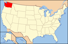
 Estados Unidos
 Washington
 Portal:Washington. Contenido relacionado con Washington.
 Wikimedia Commons alberga contenido multimedia sobre Chimacum (Washington). Commons
