Shikotan

Shikotan
Shikotan
(Шикотан)
Localización
País Bandera de Rusia Rusia
Óblast Óblast de Sajalín
Océano Océano Pacífico
Coordenadas 48°30′12″N 146°45′00″E / 48.50333, 146.75Coordenadas: 48°30′12″N 146°45′00″E / 48.50333, 146.75
Geografía
Superficie 225 km km²
Punto más alto 413 msnm

Demis - Shikotan.png
Shikotan

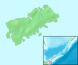
Shikotan (en ruso: Шикотан, y en japonés: Shikotan) es una isla rusa en el archipiélago de las Kuriles. Tiene una superficie de 250 km². Pertenece al grupo de las Kuriles meridionales. Japón mantiene con Rusia una disputa por esta isla, ya que la reclama desde antaño.

En la isla hay dos pequeñas localidades, Malokurilskoe y Krabozavodskoe.

Geografía

La isla de Shikotan se encuentra entre las coordenadas geográficas siguientes:

Al noroeste se encuentra la isla Kunashir, separada por el estrecho de las Kuriles Meridionales, y al suroeste las islas Jabomai, por el estrecho de Spanberg.

Administrativamente es controlada por el óblast de Sajalín.


Wikimedia foundation. 2010.

Игры ⚽ Поможем решить контрольную работу

Mira otros diccionarios:

  • Shikotan — bezeichnet: die von Russland verwaltete, aber von Japan beanspruchte Insel: Schikotan einen Landkreis darauf: Shikotan gun (Hokkaidō) ein Dorf in diesem Landkreis: heute: Malokurilsk …   Deutsch Wikipedia

  • Shikotan — Infobox Disputed Islands name = Shikotan image caption = NASA picture of Shikotan Island image size = 300px locator map custom = yes native name = native name link = other names = ru. Шикотан; ja. 色丹島 location = Pacific Ocean coordinates =… …   Wikipedia

  • Shikotan — Shikotạn   [ʃ ], russisch Schikotạn, Šikotạn [ʃi ], Insel im Pazifik, östlich der Kurileninsel Kunaschir (Kunashiri), 255 km2, bis 412 m über dem Meeresspiegel; wie die Habomai Inseln nicht vulkanischen Ursprungs. Die Vegetation bilden… …   Universal-Lexikon

  • Shikotan — Original name in latin Шикотан Name in other language Shikotan, Шикотан State code RU Continent/City Asia/Magadan longitude 43.79985 latitude 146.72138 altitude 28 Population 2100 Date 2009 02 24 …   Cities with a population over 1000 database

  • Shikotan District, Hokkaidō — nihongo|Shikotan|色丹郡| gun is a district located on Shikotan Island claimed by Japan as part of Nemuro Subprefecture, Hokkaidō. As of August 15, 1945, it had a population of 1,038. Villages * Shikotan History *1885 Split off Hanasaki District,… …   Wikipedia

  • Shikotan — Chikotan Chikotan Шикотан (ru) Carte de Chikotan. Géographie Pays …   Wikipédia en Français

  • Kuril Islands dispute — Coordinates: 44°6′N 146°42′E / 44.1°N 146.7°E / 44.1; 146.7 …   Wikipedia

  • Südkurilen — Lage der Kurilen zwischen Hokkaidō und Kamtschatka Die Kurilen, Sachalin (links), Hokkaidō (links unten) und Kamtschatka (rechts oben) (NASA Satellitenfoto) Di …   Deutsch Wikipedia

  • Kurilen — Lage der Kurilen zwischen Hokkaidō und Kamtschatka Gewässer Pazifischer Ozean …   Deutsch Wikipedia

  • Japan–Soviet Union relations — Relations between the Soviet Union (1922 1991) and Japan were always tense. For one, both countries were in opposite camps during the Cold War. A second strain on relations is territorial conflicts, dealing with both the Kuril Islands dispute and …   Wikipedia

Compartir el artículo y extractos

Link directo
Do a right-click on the link above
and select “Copy Link”